


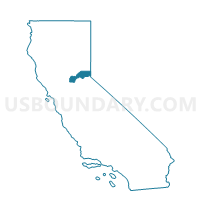
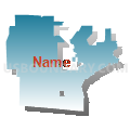
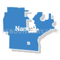
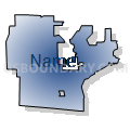
Voting District 40065, Placer County, California
About
Outline

Summary
| Unique Area Identifier | 536735 |
| Name | Voting District 40065 |
| County | Placer County |
| State | California |
| Area (square miles) | 10.00 |
| Land Area (square miles) | 9.97 |
| Water Area (square miles) | 0.03 |
| % of Land Area | 99.72 |
| % of Water Area | 0.28 |
| Latitude of the Internal Point | 38.73986670 |
| Longtitude of the Internal Point | -121.20253060 |
Maps


Graphs
Select a template below for downloading or customizing gragh for Voting District 40065, Placer County, California


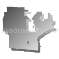


Neighbors
Neighoring Voting District (by Name) Neighboring Voting District on the Map
- Voting District 40001, Placer County, CA
- Voting District 40002, Placer County, CA
- Voting District 40020, Placer County, CA
- Voting District 40025, Placer County, CA
- Voting District 40060, Placer County, CA
- Voting District 40075, Placer County, CA
- Voting District 40080, Placer County, CA
- Voting District 40085, Placer County, CA
- Voting District 40105, Placer County, CA
- Voting District 40110, Placer County, CA
- Voting District 40115, Placer County, CA
- Voting District 40120, Placer County, CA
- Voting District 40125, Placer County, CA
- Voting District 40130, Placer County, CA
- Voting District 40145, Placer County, CA
- Voting District 40150, Placer County, CA
- Voting District 40973, Sacramento County, CA
- Voting District 40976, Sacramento County, CA
- Voting District 41048, Sacramento County, CA
- Voting District 41126, Sacramento County, CA
Top 10 Neighboring County Subdivision (by Population) Neighboring County Subdivision on the Map
- Sacramento CCD, Sacramento County, CA (1,072,790)
- Roseville CCD, Placer County, CA (115,374)
- Rocklin CCD, Placer County, CA (85,223)
- Folsom CCD, Sacramento County, CA (72,163)
Top 10 Neighboring Place (by Population) Neighboring Place on the Map
- Roseville city, CA (118,788)
- Folsom city, CA (72,203)
- Orangevale CDP, CA (33,960)
- Granite Bay CDP, CA (20,402)
Top 10 Neighboring Elementary School District (by Population) Neighboring Elementary School District on the Map
- Roseville City Elementary School District, CA (82,163)
- Eureka Union Elementary School District, CA (26,800)
- Loomis Union Elementary School District, CA (19,259)
Top 10 Neighboring Secondary School District (by Population) Neighboring Secondary School District on the Map
- Roseville Joint Union High School District, CA (161,902)
- Placer Union High School District, CA (85,905)
Top 10 Neighboring Unified School District (by Population) Neighboring Unified School District on the Map
Top 10 Neighboring State Legislative District Lower Chamber (by Population) Neighboring State Legislative District Lower Chamber on the Map
Top 10 Neighboring State Legislative District Upper Chamber (by Population) Neighboring State Legislative District Upper Chamber on the Map
Top 10 Neighboring 111th Congressional District (by Population) Neighboring 111th Congressional District on the Map
Top 10 Neighboring Census Tract (by Population) Neighboring Census Tract on the Map
- Census Tract 206.02, Placer County, CA (6,970)
- Census Tract 206.01, Placer County, CA (6,911)
- Census Tract 206.05, Placer County, CA (5,826)
- Census Tract 206.04, Placer County, CA (5,589)
- Census Tract 82.10, Sacramento County, CA (5,472)
- Census Tract 207.11, Placer County, CA (4,372)
- Census Tract 206.06, Placer County, CA (4,303)
- Census Tract 207.17, Placer County, CA (3,118)
- Census Tract 82.11, Sacramento County, CA (2,871)